
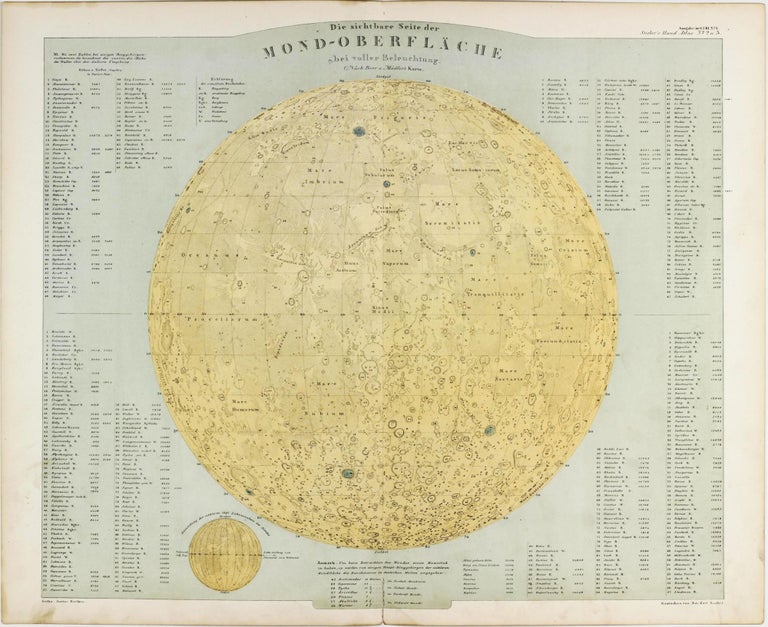
Die sichtbare Seite der Mond-Oberfläche bei voller Beleuchtung nach Beer u. Mädler's Karte.
Gotha: Justus Perthes, 1875.
No Binding. Very Good. Item #002743
Sheet no. 1 of Stieler's Handatlas. Gotha: Justus Perthes, [ca. 1875]. Chromolithographed lunar map on folding single sheet, 374 x 460 mm, engraved by Joh. Carl Ausfeld. Short tear at fold, little age-toning and marginal dust-soiling. From a later edition of the popular geographical atlas by Stieler. ----
A map after Beer and Mädler of the full moon, here projected north-up and thus opposite to the original Beer and Mädler projections. Scale approx. 1:13,000,000. Height and depth values of 198 topographical features are given in Paris foot. The map itself deviates slightly from the original Beer & Mädler maps. In addition to the large map, there is a small illustration demonstrating the daily changes of lunar phase.
Price: 500 € * convert currency
Delivery time up to 10 days. For calculation of the latest delivery date, follow the link: Delivery times
Lieferzeit max. 10 Tage. Zur Berechnung des spätesten Liefertermins siehe hier: Lieferzeiten